


Key Market Highlights
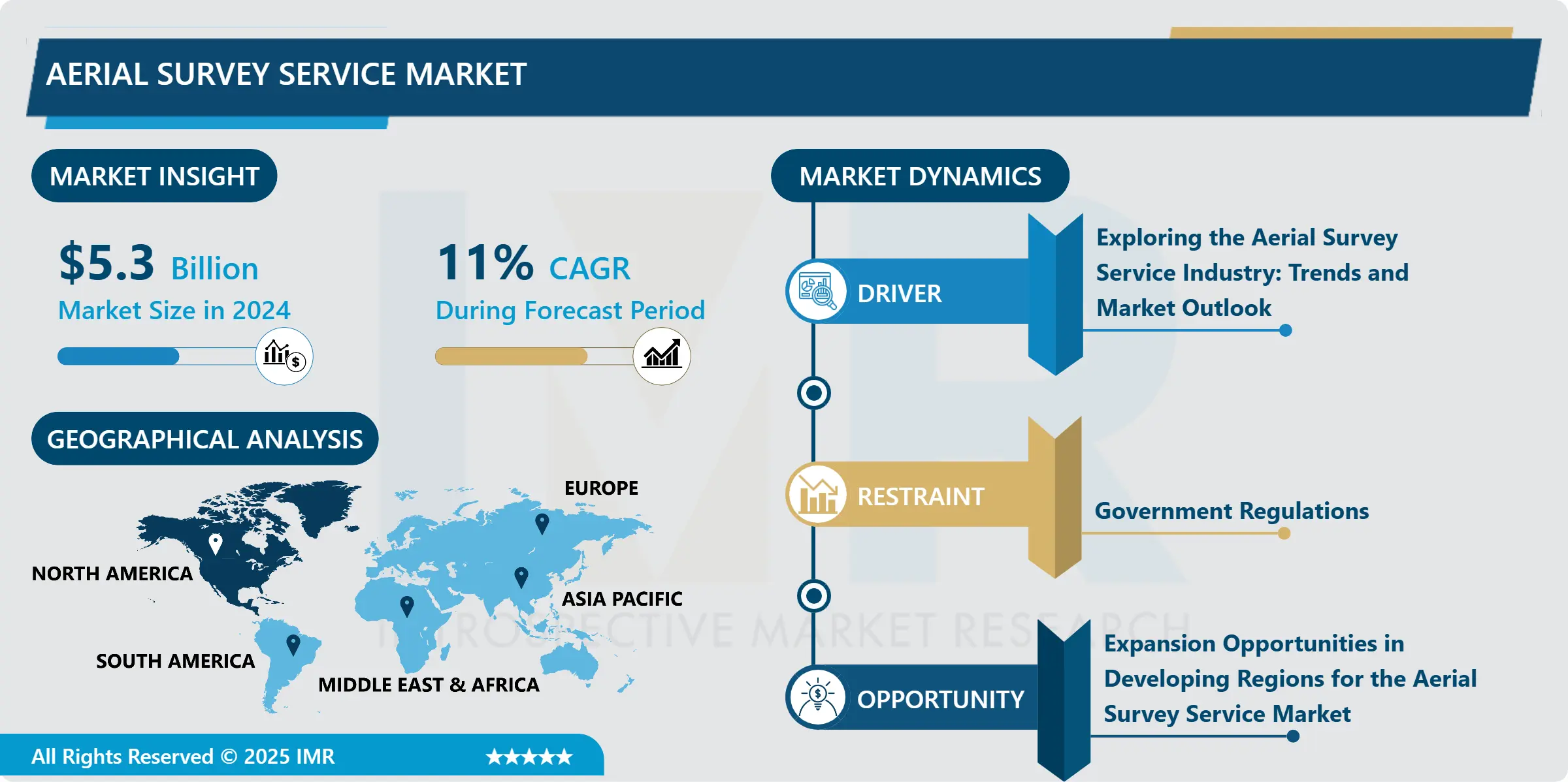
Aerial Survey Service Market Size Was Valued at USD 5.3 Billion in 2024, and is Projected to Reach USD 16.7 Billion by 2035, Growing at a CAGR of 11% from 2025-2035.
- Market Size in 2024: USD 5.3 Billion
- Projected Market Size by 2035: USD 16.7 Billion
- CAGR (2025–2035): 11%
- Leading Market in 2024: North America
- Fastest-Growing Market: Asia-Pacific
- By Type : The Unmanned Aerial Vehicles segment is anticipated to lead the market by accounting for 45% of the market share throughout the forecast period.
- By Application : The Manned aircraft segment is expected to capture 38% of the market share, thereby maintaining its dominance over the forecast period.
- By Region: The Asia Pacific region is projected to hold 33% of the market share during the forecast period.
- Active Players: 3D Laser Mapping Ltd. (United Kingdom), AAM Group (Australia), Aerometrex Ltd. (Australia), Airborne Imaging Inc. (Canada), Blom ASA (Norway), Other Active Players
Aerial Survey Service Market Synopsis:
The Global Aerial Survey Service Market is witnessing robust growth due to the increasing demand for high-resolution geospatial data across industries such as construction, agriculture, mining, oil & gas, environmental monitoring, and defence. Aerial surveys, utilizing advanced platforms like drones (UAVs), helicopters, and fixed-wing aircraft, are being increasingly adopted for their efficiency, accuracy, and ability to cover large areas quickly.
Aerial Survey Service Market Dynamics and Trend Analysis:
Aerial Survey Service Market Growth Driver – Exploring the Aerial Survey Service Industry: Trends and Market Outlook
-
The aerial survey service market is growing quickly, mainly because of the increasing use of drones and unmanned aerial vehicles (UAVs). These flying tools can take clear and detailed images of land, roads, forests, and buildings at a lower cost and in less time than older methods. They are helpful in many areas such as construction, farming, mining, and environmental studies. New technologies like LiDAR sensors, thermal cameras, and AI-powered software make drones even more useful and accurate, helping more industries use aerial surveys.
- However, there are some limitations. Many countries have strict laws about flying drones. Companies often need special licenses and must follow safety and privacy rules. In some areas, like near airports or military zones, drones are not allowed at all. These rules can slow down work and increase costs for survey companies.
- There are big opportunities in developing regions like Asia, Africa, and South America. These places are building new roads, cities, and infrastructure. Aerial surveys can help by providing accurate maps and data. As these countries grow, the need for survey services will increase. The market also faces some risks. Bad weather can delay drone flights. There is also a chance of drone crashes in rough areas. In addition, keeping data safe is important, as survey images can be sensitive. Companies need strong systems to handle these challenges.
Aerial Survey Service Market Limiting Factor - Government Regulations
-
One of the main factors slowing down the growth of the aerial survey service market is government rules and airspace restrictions. Drones and unmanned aerial vehicles (UAVs) are widely used for surveying, but they must follow strict regulations in most countries. These laws are designed to protect public safety, national security, and people’s privacy.
- In many places, drone operators must get special licenses or permissions before flying. This process can take time and may involve paperwork, training, or insurance. In certain areas, like near airports, military zones, or government buildings, flying drones is not allowed at all. Even if a company has the right equipment and skilled staff, it cannot operate freely in these zones.
- These restrictions make survey planning more difficult and can delay projects. Companies may also have to spend more money to meet legal requirements, which increases their overall costs. For smaller businesses or startups, these rules can be a major roadblock. In addition, drone laws vary from country to country, and even within different states or regions. This lack of consistency adds confusion and creates extra challenges for companies trying to operate internationally.
- While technology in aerial surveys is improving fast, legal and regulatory limits remain a big hurdle. For the market to grow smoothly, governments and industry leaders need to work together to create clear, safe, and flexible rules that support both innovation and public interest.
Aerial Survey Service Market Expansion Opportunity - Expansion Opportunities in Developing Regions for the Aerial Survey Service Market
-
One of the biggest opportunities for growth in the aerial survey service market lies in developing regions such as India, Brazil, Southeast Asia, and parts of Africa. These countries are investing heavily in infrastructure, including new roads, railways, airports, housing, and smart cities. Large-scale development like this needs careful planning and constant monitoring this is where aerial surveys become very useful.
- Aerial surveys provide fast, accurate, and detailed images of land and construction areas. These surveys help planners, engineers, and government agencies make better decisions about where and how to build. They also support regular progress tracking and quality checks during construction.
- As urbanization increases in these countries, so does the need for up-to-date mapping, land use planning, and environmental monitoring. Many governments are launching digital land records and smart infrastructure systems, which also depend on precise aerial data. What makes this opportunity even bigger is the growing use of drones, which are cheaper and easier to deploy than traditional survey aircraft. As drone technology becomes more available in developing countries, local companies can also enter the market.
- In short, the rising development in emerging economies offers a strong growth path for aerial survey service providers. Businesses that invest early in these regions can benefit from long-term contracts, new partnerships, and a strong market presence.
Aerial Survey Service Market Challenge and Risk – Overcoming Risks in the Aerial Survey Industry: Weather, Security, and Equipment
-
While the aerial survey service market is growing fast, it also faces several important challenges and risks that companies must deal with carefully. One major challenge is bad weather. Rain, strong winds, fog, or storms can delay drone flights or reduce the quality of images and data collected. Since aerial surveys depend on clear skies and good visibility, weather conditions can slow down projects or make it difficult to meet deadlines.
- Another risk is equipment failure or drone crashes. Drones often fly in rough or remote areas, such as mountains, forests, or construction zones. These environments can cause drones to crash due to signal loss, battery failure, or accidents. Replacing or repairing damaged equipment can be expensive and may lead to project delays.
- Data security is also a serious concern. Aerial surveys collect sensitive images, maps, and geographic data that may include private land, infrastructure, or government projects. If this data is stolen, leaked, or misused, it can cause legal and financial problems for both the service provider and the client.
- To handle these risks, companies need strong backup plans, secure data systems, and well-trained staff. Using high-quality drones, following safety rules, and protecting digital information are key to avoiding costly problems and keeping clients' trust. Despite these risks, proper planning and technology use can help reduce the impact and keep aerial survey projects running smoothly.
Aerial Survey Service Market Segment Analysis:
Aerial Survey Service Market is segmented based on Type, Application, End-Users, and Region
By Type, Aerial Survey Service Segment is Expected to Dominate the Market During the Forecast Period
-
Manned aircraft are one of the traditional and widely used platforms in aerial surveying. These include helicopters and fixed-wing airplanes that are flown by trained pilots. They are especially useful for large-scale surveys, where a lot of land needs to be covered in a short amount of time.
- Manned aircraft are often used for mapping entire cities, long roadways, railway lines, pipelines, coastlines, or other major infrastructure projects. Because these aircraft are bigger and stronger than drones, they can carry heavier and more advanced equipment, such as LiDAR systems, thermal sensors, hyperspectral cameras, and ultra-high-resolution cameras. This allows them to collect detailed and accurate data from high altitudes.
- However, using manned aircraft comes with some challenges. They are much more expensive to operate and maintain compared to drones. Flying them also requires licensed pilots, flight plans, and sometimes coordination with air traffic control. Additionally, they are less flexible in tight or remote areas, such as small farmlands, dense forests, or narrow valleys, where smaller UAVs are more effective.
- Even with these limitations, manned aircraft remain a valuable option for large and complex aerial survey projects. Their ability to cover vast distances and carry high-end sensors makes them a preferred choice for government agencies, urban planners, and major construction projects.
By Application, Aerial Survey Service Segment Held the Largest Share in 2024
-
Aerial survey services are becoming very helpful in the fields of agriculture and forestry. With the help of drones (UAVs) and other aerial tools, farmers and forest managers can see large areas of land from above and collect important information quickly and accurately.
- In agriculture, drones can fly over fields to take detailed images of crops. These images can show areas where plants are healthy and where they might be struggling. This helps farmers spot problems early like pests, diseases, or water shortages before they become serious. Drones can also help plan irrigation by showing which areas of the field are too dry or too wet. This is part of what’s called precision agriculture, where farmers use data to make better decisions and improve crop yields while saving water, fertilizer, and time.
- In forestry, aerial surveys are used to monitor tree health, map forest areas, and check for illegal logging or forest fires. Drones and aircraft can quickly cover large forests, even in areas that are hard to reach on foot. They help forest managers keep track of tree growth, count trees, and measure how fast forests are changing.
- Overall, aerial surveys provide fast, cost-effective, and useful information that helps both farmers and forest managers take better care of the land and use resources more efficiently.
Aerial Survey Service Market Regional Insights:
North America is Expected to Dominate the Market Over the Forecast Period
-
North America is the largest and most advanced market for aerial survey services. Countries like the United States and Canada have been using these services for many years in a wide range of industries. In the construction industry, aerial surveys are used to map large areas before building roads, bridges, or buildings. This helps engineers and planners understand the land better and avoid mistakes. In agriculture, farmers use aerial surveys to check crop health, manage irrigation, and plan harvesting. These services make farming more efficient and productive. The defence sector in North America also relies on aerial surveys for surveillance, border monitoring, and mission planning. Aerial images help the military and government track changes on land or watch for threats.
- North America has a strong base of technology companies, which makes it easier to use advanced tools like drones, LiDAR, and 3D mapping systems. Many top drone manufacturers and aerial survey firms are based in the U.S. and Canada.
- Another reason for the region’s success is its favourable regulations. The U.S. Federal Aviation Administration (FAA) and other agencies allow commercial drone use under clear rules, which supports business growth. Because of its early adoption of aerial technology, strong tech infrastructure, and wide range of applications, North America is expected to continue leading the global aerial survey market in the coming years.
Aerial Survey Service Market Active Players:
- 3D Laser Mapping Ltd. (United Kingdom)
- AAM Group (Australia)
- Aerometrex Ltd. (Australia)
- Airborne Imaging Inc. (Canada)
- Blom ASA (Norway)
- Bluesky International Ltd. (United Kingdom)
- Cyient Ltd. (India)
- Delair (France)
- DJI (SZ DJI Technology Co., Ltd.) (China)
- DroneDeploy (United States)
- Fugro (Netherlands)
- GeoIQ (India)
- GeoSense (Greece)
- Harris Geospatial Solutions (L3Harris) (United States)
- Hexagon AB (through Leica Geosystems) (Sweden)
- Kucera International Inc. (United States)
- Landiscor Real Estate Mapping (United States)
- Lidar USA (United States)
- Nearmap Ltd. (Australia)
- PASCO Corporation (Japan)
- Phase One A/S (Denmark)
- PrecisionHawk (United States)
- Quantum Spatial (a Woolpert Company) (United States)
- RIEGL Laser Measurement Systems (Austria)
- SenseFly (Part of AgEagle Aerial Systems) (Switzerland)
- Sky Futures Ltd. (United Kingdom)
- Skycatch Inc. (United States)
- Teledyne Geospatial (United States)
- Terra Drone Corporation (Japan)
- Topcon Positioning Systems (United States)
- Other Active Players
|
Aerial Survey Service Market |
|||
|
Base Year: |
2024 |
Forecast Period: |
2025-2035 |
|
Historical Data: |
2018 to 2024 |
Market Size in 2024: |
USD 5.3 Billion |
|
Forecast Period 2025-35 CAGR: |
11% |
Market Size in 2035: |
USD 16.7 Billion |
|
Segments Covered: |
By Type |
|
|
|
By Application
|
|
||
|
By Technology |
|
||
|
By End-User |
|
||
|
By Service Type |
|
||
|
By Region |
|
||
|
Growth Driver: |
|
||
|
Limiting Factor |
|
||
|
Expansion Opportunity |
|
||
|
Challenge and Risk |
|
||
|
Companies Covered in the Report: |
|
||
Chapter 1: Introduction
1.1 Scope and Coverage
Chapter 2:Executive Summary
Chapter 3: Market Landscape
3.1 Market Dynamics and Opportunity Analysis
3.1.1 Growth Drivers
3.1.2 Limiting Factors
3.1.3 Growth Opportunities
3.1.4 Challenges and Risks
3.2 Market Trend Analysis
3.3 Industry Ecosystem
3.4 Industry Value Chain Mapping
3.5 Strategic PESTLE Overview
3.6 Porter's Five Forces Framework
3.7 Regulatory Framework
3.8 Pricing Trend Analysis
3.9 Intellectual Property Review
3.10 Technology Evolution
3.11 Import-Export Analysis
3.12 Consumer Behavior Analysis
3.13 Investment Pocket Analysis
3.14 Go-To Market Strategy
Chapter 4: Aerial Survey Services Market by Type of Aerial Platforms (2018-2035)
4.1 Aerial Survey Services Market Snapshot and Growth Engine
4.2 Market Overview
4.3 Manned Aircraft
4.3.1 Introduction and Market Overview
4.3.2 Historic and Forecasted Market Size in Value USD and Volume Units
4.3.3 Key Market Trends, Growth Factors, and Opportunities
4.3.4 Geographic Segmentation Analysis
4.4 Unmanned Aerial Vehicles (UAVs)
Chapter 5: Aerial Survey Services Market by Application (2018-2032)
5.1 Aerial Survey Services Market Snapshot and Growth Engine
5.2 Market Overview
5.3 Agriculture and Forestry
5.3.1 Introduction and Market Overview
5.3.2 Historic and Forecasted Market Size in Value USD and Volume Units
5.3.3 Key Market Trends, Growth Factors, and Opportunities
5.3.4 Geographic Segmentation Analysis
5.4 Real Estate and Construction
Chapter 6: Aerial Survey Services Market by Technology (2018-2035)
6.1 Aerial Survey Services Market Snapshot and Growth Engine
6.2 Market Overview
6.3 Optical Sensing
6.3.1 Introduction and Market Overview
6.3.2 Historic and Forecasted Market Size in Value USD and Volume Units
6.3.3 Key Market Trends, Growth Factors, and Opportunities
6.3.4 Geographic Segmentation Analysis
6.4 LiDAR (Light Detection and Ranging)
Chapter 7: Aerial Survey Services Market by End-User (2018-2035)
7.1 Aerial Survey Services Market Snapshot and Growth Engine
7.2 Market Overview
7.3 Government and Defence
7.3.1 Introduction and Market Overview
7.3.2 Historic and Forecasted Market Size in Value USD and Volume Units
7.3.3 Key Market Trends, Growth Factors, and Opportunities
7.3.4 Geographic Segmentation Analysis
7.4 Agricultural Companies
Chapter 8: Aerial Survey Services Market by Service Type (2018-2035)
8.1 Aerial Survey Services Market Snapshot and Growth Engine
8.2 Market Overview
8.3 Data Collection and Processing
8.3.1 Introduction and Market Overview
8.3.2 Historic and Forecasted Market Size in Value USD and Volume Units
8.3.3 Key Market Trends, Growth Factors, and Opportunities
8.3.4 Geographic Segmentation Analysis
8.4 Surveying and Mapping Services
Chapter 9: Company Profiles and Competitive Analysis
9.1 Competitive Landscape
9.1.1 Competitive Benchmarking
9.1.2 Aerial Survey Services Market Share by Manufacturer/Service Provider(2024)
9.1.3 Industry BCG Matrix
9.1.4 PArtnerships, Mergers & Acquisitions
9.2 3D LASER MAPPING LTD. (UNITED KINGDOM)
9.2.1 Company Overview
9.2.2 Key Executives
9.2.3 Company Snapshot
9.2.4 Role of the Company in the Market
9.2.5 Sustainability and Social Responsibility
9.2.6 Operating Business Segments
9.2.7 Product Portfolio
9.2.8 Business Performance
9.2.9 Recent News & Developments
9.2.10 SWOT Analysis
9.3 AAM GROUP (AUSTRALIA)
9.4 AEROMETREX LTD. (AUSTRALIA)
9.5 AIRBORNE IMAGING INC. (CANADA)
9.6 BLOM ASA (NORWAY)
9.7 BLUESKY INTERNATIONAL LTD. (UNITED KINGDOM)
9.8 CYIENT LTD. (INDIA)
9.9 DELAIR (FRANCE)
9.10 DJI (SZ DJI TECHNOLOGY CO.
9.11 LTD.) (CHINA)
9.12 DRONEDEPLOY (UNITED STATES)
9.13 FUGRO (NETHERLANDS)
9.14 GEOIQ (INDIA)
9.15 GEOSENSE (GREECE)
9.16 HARRIS GEOSPATIAL SOLUTIONS (L3HARRIS) (UNITED STATES)
9.17 HEXAGON AB (THROUGH LEICA GEOSYSTEMS) (SWEDEN)
9.18 KUCERA INTERNATIONAL INC. (UNITED STATES)
9.19 LANDISCOR REAL ESTATE MAPPING (UNITED STATES)
9.20 LIDAR USA (UNITED STATES)
9.21 NEARMAP LTD. (AUSTRALIA)
9.22 PASCO CORPORATION (JAPAN)
9.23 PHASE ONE A/S (DENMARK)
9.24 PRECISIONHAWK (UNITED STATES)
9.25 QUANTUM SPATIAL (A WOOLPERT COMPANY) (UNITED STATES)
9.26 RIEGL LASER MEASUREMENT SYSTEMS (AUSTRIA)
9.27 SENSEFLY (PART OF AGEAGLE AERIAL SYSTEMS) (SWITZERLAND)
9.28 SKY FUTURES LTD. (UNITED KINGDOM)
9.29 SKYCATCH INC. (UNITED STATES)
9.30 TELEDYNE GEOSPATIAL (UNITED STATES)
9.31 TERRA DRONE CORPORATION (JAPAN)
9.32 TOPCON POSITIONING SYSTEMS (UNITED STATES)
9.33 AND OTHER ACTIVE PLAYERS.
Chapter 10: Global Aerial Survey Services Market By Region
10.1 Overview
10.2. North America Aerial Survey Services Market
10.2.1 Key Market Trends, Growth Factors and Opportunities
10.2.2 Top Key Companies
10.2.3 Historic and Forecasted Market Size by Segments
10.2.4 Historic and Forecast Market Size by Country
10.2.4.1 US
10.2.4.2 Canada
10.2.4.3 Mexico
10.3. Eastern Europe Aerial Survey Services Market
10.3.1 Key Market Trends, Growth Factors and Opportunities
10.3.2 Top Key Companies
10.3.3 Historic and Forecasted Market Size by Segments
10.3.4 Historic and Forecast Market Size by Country
10.3.4.1 Russia
10.3.4.2 Bulgaria
10.3.4.3 The Czech Republic
10.3.4.4 Hungary
10.3.4.5 Poland
10.3.4.6 Romania
10.3.4.7 Rest of Eastern Europe
10.4. Western Europe Aerial Survey Services Market
10.4.1 Key Market Trends, Growth Factors and Opportunities
10.4.2 Top Key Companies
10.4.3 Historic and Forecasted Market Size by Segments
10.4.4 Historic and Forecast Market Size by Country
10.4.4.1 Germany
10.4.4.2 UK
10.4.4.3 France
10.4.4.4 The Netherlands
10.4.4.5 Italy
10.4.4.6 Spain
10.4.4.7 Rest of Western Europe
10.5. Asia Pacific Aerial Survey Services Market
10.5.1 Key Market Trends, Growth Factors and Opportunities
10.5.2 Top Key Companies
10.5.3 Historic and Forecasted Market Size by Segments
10.5.4 Historic and Forecast Market Size by Country
10.5.4.1 China
10.5.4.2 India
10.5.4.3 Japan
10.5.4.4 South Korea
10.5.4.5 Malaysia
10.5.4.6 Thailand
10.5.4.7 Vietnam
10.5.4.8 The Philippines
10.5.4.9 Australia
10.5.4.10 New Zealand
10.5.4.11 Rest of APAC
10.6. Middle East & Africa Aerial Survey Services Market
10.6.1 Key Market Trends, Growth Factors and Opportunities
10.6.2 Top Key Companies
10.6.3 Historic and Forecasted Market Size by Segments
10.6.4 Historic and Forecast Market Size by Country
10.6.4.1 Turkiye
10.6.4.2 Bahrain
10.6.4.3 Kuwait
10.6.4.4 Saudi Arabia
10.6.4.5 Qatar
10.6.4.6 UAE
10.6.4.7 Israel
10.6.4.8 South Africa
10.7. South America Aerial Survey Services Market
10.7.1 Key Market Trends, Growth Factors and Opportunities
10.7.2 Top Key Companies
10.7.3 Historic and Forecasted Market Size by Segments
10.7.4 Historic and Forecast Market Size by Country
10.7.4.1 Brazil
10.7.4.2 Argentina
10.7.4.3 Rest of SA
Chapter 11 Analyst Viewpoint and Conclusion
Chapter 12 Our Thematic Research Methodology
12.1 Research Process
12.2 Primary Research
12.3 Secondary Research
Chapter 13 Case Study
Chapter 14 Appendix
14.1 Sources
14.2 List of Tables and figures
14.3 Short Forms and Citations
14.4 Assumption and Conversion
14.5 Disclaimer
|
Aerial Survey Service Market |
|||
|
Base Year: |
2024 |
Forecast Period: |
2025-2035 |
|
Historical Data: |
2018 to 2024 |
Market Size in 2024: |
USD 5.3 Billion |
|
Forecast Period 2025-35 CAGR: |
11% |
Market Size in 2035: |
USD 16.7 Billion |
|
Segments Covered: |
By Type |
|
|
|
By Application
|
|
||
|
By Technology |
|
||
|
By End-User |
|
||
|
By Service Type |
|
||
|
By Region |
|
||
|
Growth Driver: |
|
||
|
Limiting Factor |
|
||
|
Expansion Opportunity |
|
||
|
Challenge and Risk |
|
||
|
Companies Covered in the Report: |
|
||


